Template:Attached KML/WS postcode area
KML is from Wikidata
Walsall | |
|---|---|
 WS | |
| Coordinates: 52°38′53″N 1°57′18″W / 52.648°N 1.955°W | |
| Country | United Kingdom |
| Postcode area | WS |
| Postcode area name | Walsall |
| Post towns | 6 |
| Postcode districts | 15 |
| Postcode sectors | 67 |
| Postcodes (live) | 10,089 |
| Postcodes (total) | 14,838 |
| Statistics as at May 2020[1] | |
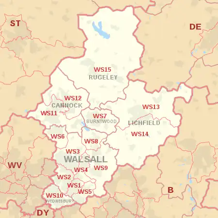
The WS postcode area, also known as the Walsall postcode area,[2] is a group of fifteen postcode districts in England, within six post towns. These cover the northern part of the West Midlands (including Walsall and Wednesbury) and much of south-east Staffordshire (including Lichfield, Cannock, Burntwood and Rugeley).
Coverage
The approximate coverage of the postcode districts:
| Postcode district | Post town | Coverage | Local authority area(s) |
|---|---|---|---|
| WS1 | WALSALL | Walsall town centre, Caldmore | Walsall |
| WS2 | WALSALL | Pleck, Bentley, Leamore | Walsall |
| WS3 | WALSALL | Bloxwich, Coal Pool, Pelsall | Walsall |
| WS4 | WALSALL | Rushall | Walsall |
| WS5 | WALSALL | Bescot, Tamebridge, Yew Tree | Walsall |
| WS6 | WALSALL | Cheslyn Hay, Great Wyrley | South Staffordshire |
| WS7 | BURNTWOOD | Burntwood | Lichfield |
| WS8 | WALSALL | Brownhills, Walsall Wood (north) | Walsall |
| WS9 | WALSALL | Aldridge, Walsall Wood (south), Stonnall | Walsall, Lichfield |
| WS10 | WEDNESBURY | Wednesbury, Darlaston | Sandwell, Walsall |
| WS11 | CANNOCK | Cannock, Norton Canes, Hatherton | Cannock Chase, South Staffordshire |
| WS12 | CANNOCK | Hednesford, Heath Hayes, Wimblebury, Huntington | Cannock Chase, South Staffordshire |
| WS13 | LICHFIELD | Lichfield (north and city centre), Fradley, Streethay, Croxall, Farewell, Chorley | Lichfield |
| WS14 | LICHFIELD | Lichfield (south), Shenstone, Whittington, Wall, Weeford | Lichfield |
| WS15 | RUGELEY | Rugeley, Brereton, Armitage, Handsacre, Abbots Bromley, Longdon, Mavesyn Ridware, Hill Ridware, Blithbury, Colton, Cannock Wood, Gentleshaw, Hamstall Ridware, Admaston | Cannock Chase, Lichfield, East Staffordshire |
Map
Template:Attached KML/WS postcode area
KML is from Wikidata
See also
References
- ↑ "ONS Postcode Directory Version Notes" (ZIP). National Statistics Postcode Products. Office for National Statistics. May 2020. Table 2. Retrieved 19 June 2020. Coordinates from mean of unit postcode points, "Code-Point Open". OS OpenData. Ordnance Survey. February 2012. Retrieved 21 April 2012.
- ↑ Royal Mail, Address Management Guide, (2004)
External links
This article is issued from Wikipedia. The text is licensed under Creative Commons - Attribution - Sharealike. Additional terms may apply for the media files.