| Windberg | |
|---|---|
 | |
| Highest point | |
| Elevation | 353 m (1,158 ft) |
| Coordinates | 50°59′49″N 13°39′39″E / 50.99694°N 13.66083°E |
| Geography | |
| Parent range | Döhlen Basin |
| Geology | |
| Age of rock | Rotliegendes |
| Mountain type | conglomerate with hard coal seams |

The Windberg (353 m above NN) is a hill in the borough of Freital near Dresden in the German federal state of Saxony. It is the town's Hausberg or local hill.
Geomorphology and natural features
The Windberg has a striking silhouette, visible from afar. Its narrow northwestern slope opens out into a long, broad and thickly wooded plateau. The hill has been designated as a nature reserve and protected area since 1967 due to its near-natural woodland and rich flora and fauna. Its tectonic cleft cavern, known as the Windbergspalte,[1] is the deepest cave in Saxony with a depth of 44 metres (144 ft).
Gallery
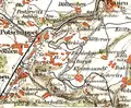 Section of an 1895 overview map with the Windberg
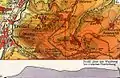 1930 topographical map of the Windberg with contours
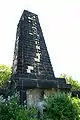 King Albert Monument on the Windberg
 View from Freital-Wurgwitz of the Windberg
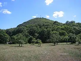
References
- ↑ Sächsischer Höhlenkataster Nr. 5047/EG-12
Sources
- Haus der Heimat Freital (Hg.): Der Windberg, Freital 1986
External links
Wikimedia Commons has media related to Windberg (Freital).
This article is issued from Wikipedia. The text is licensed under Creative Commons - Attribution - Sharealike. Additional terms may apply for the media files.