Domfessel | |
|---|---|
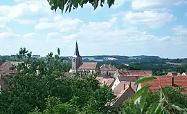 A general view of Domfessel | |
.svg.png.webp) Coat of arms | |
Location of Domfessel | |
 Domfessel 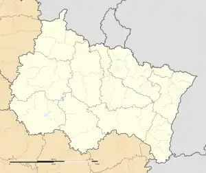 Domfessel | |
| Coordinates: 48°57′06″N 7°09′15″E / 48.9517°N 7.1542°E | |
| Country | France |
| Region | Grand Est |
| Department | Bas-Rhin |
| Arrondissement | Saverne |
| Canton | Ingwiller |
| Government | |
| • Mayor (2020–2026) | Charles Kuchly[1] |
| Area 1 | 6.23 km2 (2.41 sq mi) |
| Population | 278 |
| • Density | 45/km2 (120/sq mi) |
| Time zone | UTC+01:00 (CET) |
| • Summer (DST) | UTC+02:00 (CEST) |
| INSEE/Postal code | 67099 /67430 |
| Elevation | 217–343 m (712–1,125 ft) |
| 1 French Land Register data, which excludes lakes, ponds, glaciers > 1 km2 (0.386 sq mi or 247 acres) and river estuaries. | |
Domfessel is a commune in the Bas-Rhin department in Grand Est in north-eastern France.[3] As with other parts of Alsace and Bas-Rhin, Domfessel has had periods under German rule, and its name is Germanic. Domfessel has been part of France since 1790, with an interlude of German rule 1871-1919.
See also
References
- ↑ "Répertoire national des élus: les maires" (in French). data.gouv.fr, Plateforme ouverte des données publiques françaises. 13 September 2022.
- ↑ "Populations légales 2021". The National Institute of Statistics and Economic Studies. 28 December 2023.
- ↑ INSEE commune file
Wikimedia Commons has media related to Domfessel.
This article is issued from Wikipedia. The text is licensed under Creative Commons - Attribution - Sharealike. Additional terms may apply for the media files.