Saint-Pierre | |
|---|---|
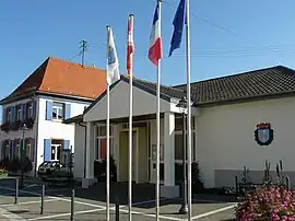 The town hall in Saint-Pierre | |
.svg.png.webp) Coat of arms | |
Location of Saint-Pierre | |
 Saint-Pierre 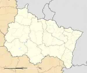 Saint-Pierre | |
| Coordinates: 48°23′05″N 7°28′18″E / 48.3847°N 7.4717°E | |
| Country | France |
| Region | Grand Est |
| Department | Bas-Rhin |
| Arrondissement | Sélestat-Erstein |
| Canton | Obernai |
| Government | |
| • Mayor (2020–2026) | Denis Ruxer[1] |
| Area 1 | 3.21 km2 (1.24 sq mi) |
| Population | 613 |
| • Density | 190/km2 (490/sq mi) |
| Time zone | UTC+01:00 (CET) |
| • Summer (DST) | UTC+02:00 (CEST) |
| INSEE/Postal code | 67429 /67140 |
| Elevation | 169–208 m (554–682 ft) |
| 1 French Land Register data, which excludes lakes, ponds, glaciers > 1 km2 (0.386 sq mi or 247 acres) and river estuaries. | |
Saint-Pierre (French pronunciation: [sɛ̃ pjɛʁ] ⓘ; German: Sankt Peter; Alemannic: Sàm-Peeter) is a commune in the Bas-Rhin department, Alsace, north-eastern France.[3]
See also
References
- ↑ "Répertoire national des élus: les maires". data.gouv.fr, Plateforme ouverte des données publiques françaises (in French). 2 December 2020.
- ↑ "Populations légales 2021". The National Institute of Statistics and Economic Studies. 28 December 2023.
- ↑ INSEE commune file
Wikimedia Commons has media related to Saint-Pierre (Bas-Rhin).
This article is issued from Wikipedia. The text is licensed under Creative Commons - Attribution - Sharealike. Additional terms may apply for the media files.