Gournay-en-Bray | |
|---|---|
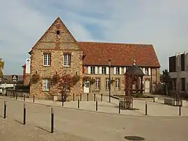 Tourism office | |
 Coat of arms | |
Location of Gournay-en-Bray | |
 Gournay-en-Bray  Gournay-en-Bray | |
| Coordinates: 49°28′53″N 1°43′29″E / 49.4814°N 1.7247°E | |
| Country | France |
| Region | Normandy |
| Department | Seine-Maritime |
| Arrondissement | Dieppe |
| Canton | Gournay-en-Bray |
| Intercommunality | CC 4 rivières |
| Government | |
| • Mayor (2020–2026) | Éric Picard[1] |
| Area 1 | 10.4 km2 (4.0 sq mi) |
| Population | 5,944 |
| • Density | 570/km2 (1,500/sq mi) |
| Time zone | UTC+01:00 (CET) |
| • Summer (DST) | UTC+02:00 (CEST) |
| INSEE/Postal code | 76312 /76220 |
| Elevation | 84–133 m (276–436 ft) (avg. 94 m or 308 ft) |
| 1 French Land Register data, which excludes lakes, ponds, glaciers > 1 km2 (0.386 sq mi or 247 acres) and river estuaries. | |
Gournay-en-Bray (French pronunciation: [guʁnɛ ɑ̃ bʁɛ]) is a commune in the Seine-Maritime department in the Normandy region in north-western France.
Geography
A town of farming and light industry, it is situated in the Pays de Bray, some 50 km (31 mi) east of Rouen, at the junction of the N 31, the D 915 and the D 930 roads.
The commune's territory includes three former parish hamlets, near the confluence of the Epte with three other smaller rivers – the Morette, Auchy and Aulnaie.
Population
| Year | Pop. | ±% p.a. |
|---|---|---|
| 1968 | 5,791 | — |
| 1975 | 6,430 | +1.51% |
| 1982 | 6,344 | −0.19% |
| 1990 | 6,147 | −0.39% |
| 1999 | 6,275 | +0.23% |
| 2007 | 6,174 | −0.20% |
| 2012 | 6,409 | +0.75% |
| 2017 | 6,072 | −1.07% |
| Source: INSEE[3] | ||
Heraldry
Arms of Gournay-en-Bray |
The arms of Gournay-en-Bray are blazoned: Sable, an armed knight contourny maintaining in his right hand a lance argent, and in chief a fleur-de-lys Or. The traditional armoury of the Counts of Gournay seems to have been Sable simple (a pure black shield with nothing on it), hence the sable field here.
|
Places of interest
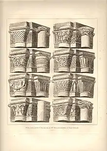
- The Collegiate Church of Saint-Hildevert, built in the 12th century, is famous for its Romanesque capitals, ornate decoration and its ancient religious sculptures.
- Vestiges of a 17th-century priory, now a farm
- Ruins of a 12th-century Capuchin monastery
- The chapel at the hamlet of Saint-Clair, built in 1829
- A memorial fountain of the 18th century
- The town gates and fortifications, dating from the 13th century
- Traces of 10th-century fortifications
- The 16th-century church of Saint-Jean-Batiste
International relations
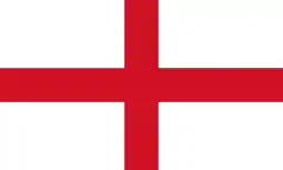 Hailsham, England
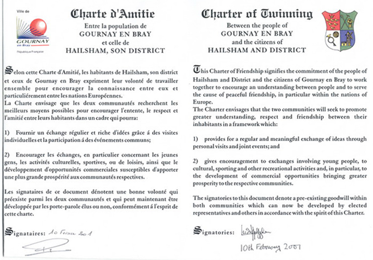
Gournay-en-Bray is twinned with Hailsham in the English County of East Sussex. Hailsham has a much larger population (circa 20,500 compared to Gournay-en-Bray's circa 6,500) but, according to Hailsham Town Council, "the features and facilities of both towns are quite similar".[4] A twinning charter[5] was signed in Hailsham in October 2000 and in Gournay-en-Bray in February 2001, and renewed in both towns on its 10th anniversary.[6]
Notable people
- Henri-Michel Guedier de Saint-Aubin (1695-1742), theologian and Sorbonne professor
See also
References
- ↑ "Répertoire national des élus: les maires" (in French). data.gouv.fr, Plateforme ouverte des données publiques françaises. 13 September 2022.
- ↑ "Populations légales 2021". The National Institute of Statistics and Economic Studies. 28 December 2023.
- ↑ Population en historique depuis 1968, INSEE
- ↑ Page re twinning on web site of Hailsham Town Council Archived 2012-07-22 at the Wayback Machine
- ↑ "Charter of Twinning". Retrieved 2021-01-07.
- ↑ Hailsham and District Twinning Association Archived 2013-10-06 at the Wayback Machine
External links
- Gournay-en-Bray official website (in French)
- Office of tourism in Gournay-en-Bray Archived 2012-02-18 at the Wayback Machine (in French)