Pierrefiques | |
|---|---|
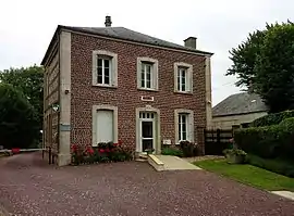 The town hall in Pierrefiques | |
.svg.png.webp) Coat of arms | |
Location of Pierrefiques | |
 Pierrefiques  Pierrefiques | |
| Coordinates: 49°40′18″N 0°13′59″E / 49.6717°N 0.2331°E | |
| Country | France |
| Region | Normandy |
| Department | Seine-Maritime |
| Arrondissement | Le Havre |
| Canton | Octeville-sur-Mer |
| Intercommunality | Le Havre Seine Métropole |
| Government | |
| • Mayor (2020–2026) | Pascal Coutey[1] |
| Area 1 | 2.31 km2 (0.89 sq mi) |
| Population | 132 |
| • Density | 57/km2 (150/sq mi) |
| Time zone | UTC+01:00 (CET) |
| • Summer (DST) | UTC+02:00 (CEST) |
| INSEE/Postal code | 76501 /76280 |
| Elevation | 15–107 m (49–351 ft) (avg. 90 m or 300 ft) |
| 1 French Land Register data, which excludes lakes, ponds, glaciers > 1 km2 (0.386 sq mi or 247 acres) and river estuaries. | |
Pierrefiques (French pronunciation: [pjɛʁfik]) is a commune in the Seine-Maritime department in the Normandy region in northern France.
Geography
A small farming village in the Pays de Caux, situated some 15 miles (24 km) northeast of Le Havre, just off the D139 road.
Population
| Year | Pop. | ±% p.a. |
|---|---|---|
| 1968 | 91 | — |
| 1975 | 79 | −2.00% |
| 1982 | 85 | +1.05% |
| 1990 | 97 | +1.66% |
| 1999 | 106 | +0.99% |
| 2007 | 123 | +1.88% |
| 2012 | 140 | +2.62% |
| 2017 | 135 | −0.72% |
| Source: INSEE[3] | ||
Places of interest
- The church of St. Jean-Baptiste, dating from the sixteenth century.
See also
References
- ↑ "Répertoire national des élus: les maires" (in French). data.gouv.fr, Plateforme ouverte des données publiques françaises. 13 September 2022.
- ↑ "Populations légales 2021". The National Institute of Statistics and Economic Studies. 28 December 2023.
- ↑ Population en historique depuis 1968, INSEE
Wikimedia Commons has media related to Pierrefiques.
This article is issued from Wikipedia. The text is licensed under Creative Commons - Attribution - Sharealike. Additional terms may apply for the media files.