Villers-le-Rond | |
|---|---|
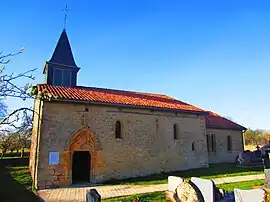 The church in Villers-le-Rond | |
.svg.png.webp) Coat of arms | |
Location of Villers-le-Rond | |
 Villers-le-Rond 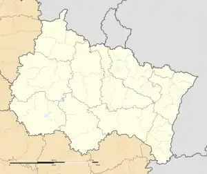 Villers-le-Rond | |
| Coordinates: 49°27′57″N 5°29′26″E / 49.4658°N 5.4906°E | |
| Country | France |
| Region | Grand Est |
| Department | Meurthe-et-Moselle |
| Arrondissement | Briey |
| Canton | Mont-Saint-Martin |
| Government | |
| • Mayor (2020–2026) | Éric Gillardin[1] |
| Area 1 | 4.5 km2 (1.7 sq mi) |
| Population | 122 |
| • Density | 27/km2 (70/sq mi) |
| Time zone | UTC+01:00 (CET) |
| • Summer (DST) | UTC+02:00 (CEST) |
| INSEE/Postal code | 54576 /54260 |
| 1 French Land Register data, which excludes lakes, ponds, glaciers > 1 km2 (0.386 sq mi or 247 acres) and river estuaries. | |
Villers-le-Rond (French pronunciation: [vilɛʁ lə ʁɔ̃]) is a commune in the Meurthe-et-Moselle department in north-eastern France.
Geography
The river Othain forms all of the commune's western border.
See also
References
- ↑ "Répertoire national des élus: les maires". data.gouv.fr, Plateforme ouverte des données publiques françaises (in French). 9 August 2021.
- ↑ "Populations légales 2021". The National Institute of Statistics and Economic Studies. 28 December 2023.
Wikimedia Commons has media related to Villers-le-Rond.
This article is issued from Wikipedia. The text is licensed under Creative Commons - Attribution - Sharealike. Additional terms may apply for the media files.