Sainte-Croix | |
|---|---|
Commune | |
 | |
.svg.png.webp) Coat of arms | |
Location of Sainte-Croix | |
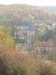
 Sainte-Croix  Sainte-Croix | |
| Coordinates: 45°53′40″N 5°03′12″E / 45.8944°N 5.0532°E | |
| Country | France |
| Region | Auvergne-Rhône-Alpes |
| Department | Ain |
| Arrondissement | Bourg-en-Bresse |
| Canton | Meximieux |
| Intercommunality | La Côtière à Montluel |
| Government | |
| • Mayor (2020–2026) | Michel Levrat[1] |
| Area 1 | 10.62 km2 (4.10 sq mi) |
| Population | 547 |
| • Density | 52/km2 (130/sq mi) |
| Time zone | UTC+01:00 (CET) |
| • Summer (DST) | UTC+02:00 (CEST) |
| INSEE/Postal code | 01342 /01120 |
| Elevation | 235–294 m (771–965 ft) |
| 1 French Land Register data, which excludes lakes, ponds, glaciers > 1 km2 (0.386 sq mi or 247 acres) and river estuaries. | |
Sainte-Croix (French pronunciation: [sɛ̃t kʁwa] ⓘ; Arpitan: Sent-Crouèx or Senta-Crouèx) is a commune in the Ain department in eastern France.
Population
| Year | Pop. | ±% p.a. |
|---|---|---|
| 1968 | 176 | — |
| 1975 | 169 | −0.58% |
| 1982 | 263 | +6.52% |
| 1990 | 365 | +4.18% |
| 1999 | 468 | +2.80% |
| 2007 | 520 | +1.33% |
| 2012 | 523 | +0.12% |
| 2017 | 570 | +1.74% |
| Source: INSEE[3] | ||
See also
References
- ↑ "Répertoire national des élus: les maires" (in French). data.gouv.fr, Plateforme ouverte des données publiques françaises. 13 September 2022.
- ↑ "Populations légales 2021". The National Institute of Statistics and Economic Studies. 28 December 2023.
- ↑ Population en historique depuis 1968, INSEE
Wikimedia Commons has media related to Sainte-Croix, Ain.
This article is issued from Wikipedia. The text is licensed under Creative Commons - Attribution - Sharealike. Additional terms may apply for the media files.